Posted using my Android
Wednesday, September 7, 2011
Feature Algebra in a Nutshell
Feature Algebra is an "algebraic form of representation that allows the use of variables and indices for the purposes of identity checking" (Reiss 2002).

Wednesday, August 31, 2011
App Stats 20 days - Conclusion: Calling for Malay localizers :)
Let's take a look at my Android Market stats during open beta testing for Iteration I Aug 9-29 : User Interface
I have a total of 15 active users according to the Android Market, most of the users have either Android 2.2 (Froyo) or 2.3.3 (Gingerbread).
Android versions:
Total active installs : 15
Naturally I have had installs in Canada and the US, but 50% of my user base is in Indonesia and Malaysia (probably my friends from Grad school) although I'm not sure how they found out about it, since I only told a couple of people that I knew that had Androids. There were also some users from Israel, Austria, Sweden, India, Lebanon and the UK. How they found AuBlog and why they downloaded it I can't guess :)
Android versions:
| 1. |  2.2 2.2 | 2,084 | 78.17% | |
| 2. | 2.3.3 | 381 | 14.29% | |
| 3. | 3.1 | 67 | 2.51% | |
| 4. | 2.2.1 | 50 | 1.88% | |
| 5. | 3.0.1 | 43 | 1.61% | |
| 6. | 2.2.2 | 20 | 0.75% | |
| 7. | 2.3.4 | 13 | 0.49% | |
| 8. | 3.2 | 7 | 0.26% | |
| 9. | (not set) | 1 | 0.04% | |
Total active installs : 15
Naturally I have had installs in Canada and the US, but 50% of my user base is in Indonesia and Malaysia (probably my friends from Grad school) although I'm not sure how they found out about it, since I only told a couple of people that I knew that had Androids. There were also some users from Israel, Austria, Sweden, India, Lebanon and the UK. How they found AuBlog and why they downloaded it I can't guess :)
1
|
Malaysia
|
26.7% (4)
|
2
|
Indonesia
|
26.7% (4)
|
3
|
United States
|
13.3% (2)
|
4
|
Canada
|
13.3% (2)
|
5
|
United Kingdom
|
6.7% (1)
|
6
|
Austria
|
6.7% (1)
|
7
|
India
|
6.7% (1)
|
The most important thing for me was to find out what kinds of devices I should target. I have tested my app with an HTC Desire (2.2), Viewsonic Gtab (2.3.3) and a Motorola Xoom (3.1) all of which have different user experience with my app.
1
|
Samsung Galaxy Mini
| |
2
|
Samsung Galaxy Tab 10.1
| |
3
|
Samsung Galaxy S2
| |
4
|
HTC Thunderbolt
| |
5
|
HTC Wildfire S
| |
6
|
LG Optimus One
| |
7
|
Samsung Galaxy Fit
| |
8
|
HTC Desire
| |
9
|
Samsung Galaxy S
| |
10
|
HTC Sensation 4G
| |
Device Testing
The HTC Desire : my everyday device.
Audio
Bluetooth works seamlessly with Aublog. This is fortunate, as this is the device I go biking with. The audio is also a much better quality using the bluetooth although it is still only 8000 hz sample rate, yielding only 4000hz sample rate which is not usable for phonetic analysis. What a 4000 hz sample rate means is that high frequency noise like the white noise in the bursts and frication of stops, fricatives and affricates is not captured.
Visual
On the visual side of things, the Javascript in the Drafts Tree consistently renders the tree and the JavaScript in the Edit Entry page also consistently saves state when I rotate the device. On the other hand, the buttons in the WebView are quite ugly, by default.
The ViewSonic GTab
Audio
It doesn't work with Bluetooth, despite having bluetooth, and successfully pairing with my bluetooth headset. It is perhaps due to a lack of a telephony system. In order to play and record audio through bluetooth, the app must actually route the audio through the telephony system in earlier versions of Android. So the fact that Bluetooth works on the HTC Desire, maybe due to the fact that it is 2.2, or that it is a phone. The Bluetooth API underwent a lot of improvements in 3.0 and beyond so hopefully it will work more consistently on the other devices. On the other hand, Android 2.3 and above allows for wide band recordings of 16,000 hz sample rate which yields a much better quality and is useable for phonetic analysis as the range needed for human speech sounds is below 8000 hz.
Visual
On the visual side of things the large screen size is fun for using the Drafts Tree! While testing I realized I started using the titles in the nodes unconsciously to document the branching test scenarios for each feature and sequence of user actions in AuBlog. It serves as a pretty quick tree generator, especially for nodes with small labels. I was planning on repackaging it into a tree drawing app for linguists, or tree thinkers. The WebView buttons are also quite visually pleasing, by default.
A question for the tablet users: can you record and hear audio with your paired bluetooth headset when you enable it in AuBlog?
The Motorola Xoom
Audio
The bluetooth and the audio on the Xoom has the same story as the GTab, no bluetooth but surprisingly good quality with the built in mic.
Visual
The Xoom was an interesting visual surprise for AuBlog. First of all, after testing heavily on the HTC, and once and a while on the GTab I didn't expect the Xoom to present such an unusable user experience. There are no hardware buttons on the Xoom, the buttons are created by the software. Moreover, there is no Menu button by default. Instead, menu items are rendered in "the Action Bar" if the app targets SDK 11, using the same underlying code. However, despite targeting SDK 11, and using best practices for menu coding, the menu didn't show up on the Xoom (probably because there are just words as menu items, not icons). To have the menu show up I changed the target to SDK 10, and now the software menu appears. The next problem with the XOOM has to do with the Drafts Tree. The drafts tree is generated when the user clicks on Drafts. The Activity calls the WebView with the static HTML page, and the HTML page loads the JSON (the tree). By initializing the tree only after the page has loaded, and the JSON has finished exporting, the tree loads properly on the HTC Desire, and also on the GTab, but not on the Xoom. At first I thought it might be due to having 2 cores (one core might be still writing the JSON to file, while the other is loading the JSON into the WebView, but the GTab also has two cores. It may also have to do with having a new WebView version. A question for the testers with Android 3.0 and up, does the Drafts tree load?
In future iterations (once I'm out of the prototyping stage and the architecture has stabilized) I was also planning on localizing AuBlog for another language to put all the mechanisms in place, my candidate languages were French (since I live in Montreal) and Inuktitut (since my informants might tell their friends about it), but it seems like Malay could be fun too since its 50% of my current users :) That is not for a few more iterations, I will wait until the architecture has stabilized further.
Architecture Growth
Itteration I Graphical User Interface : v1.0 - 4 Months
Standard Activities + WebViews for graphically interesting User Interface + Settings for persistant variables and user preferences
Most of the development time so far has been devoted to reconciling the interest of a visually pleasing user interface with maintaing state and not loosing user's entries while they type and rotate the screen. It seems like it should not be such a complex operation, but rotating the screen "destroys" and recreates the activity. Since the user is typing in a webview the Javascript interface has to save the state down to the activity in order to use the built-in state saving mechanisms. Nothing is more frustrating than loosing what you have just entered because you shifted in your chair and the screen rotated. On the other hand rotating the screen is crucial for a good user experience: some times you want to read the entry in wide screen, and then rotate to edit in portrait with the keyboard on the bottom of the screen. The user interface uses a couple of open source JavaScript libraries to make the drafts tree interactive (JIT) and the blog editing WYSIWYG (MarkItUp).
Iteration II Background Services: v1.1 - 20 days
Standard Activities + WebViews for graphically interesting User Interface + + Settings for persistant variables and user preferences + Recording and transcription server interfacing refactored into Services + Broadcasts between modules
Audio Management Services and the transcription server architecture (Node.js and PocketSphinx) was surprisingly straightforward to set up, and also the most important core of AuBlog's mission. In this iteration AuBlog supports 3 audio configurations: Bluetooth for wire-free dictation, earphones+mic for private dictation, and built-in mic and speakers for default dictation. AuBlog also supports a variety of internet connection preferences, from transcription only over Wifi, to transfers over 3G for x file sizes. In my experience dictations are between 2-4 minutes long, and result in really small files (10-15KB) so its worthwhile to send them for transcription over a 3G connection while I'm biking. I made it so that its completely configurable and users can decide what they want to automatically transcribe. I generally only send the lowest daughter on a branch for transcription since the others are drafts, I prefer to re-listen to them and reformulate them until I'm satisfied.
Iteration III Voice User Interface & Widget : v1.2 - (3 Months)
A homescreen widget for "eyes-free" bike blogging. This will encourage refactoring the code into a central "brain" which issues intents to the other components. This will also be an interesting challenge to make it as "eyes-free" as possible and set up/adopt architecture to use Google Voice to recognize app commands
"New Entry"
"Play/Read Mother Node"
"Play/Read/Record Sister Node"
"Delete Entry"
"New Daughter"
"Stop recording"
etc
After spending so much precious dev time making sure the graphical user interface's javascript libraries is functional on an Android device, I remembered that I never really wanted a visual user interface; I wanted an "eyes-free" (meaning language only) interface. So, at this point the GUI is functional, and it will stay as it is unless there are some bugs which affect its functionality. I would love to auto-resize the nodes to fit the text but that would require a lot more dev time. I'm excited to start Iteration III, the part of the app that really interests me and is the part I can contribute to most: the VUI (voice user interface). I expect this will take me more time than Iteration II, which only took 20 days. It all depends on the existing open source modules I find and how well they integrate with Android.
Wednesday, August 10, 2011
My first published app!
I published my first app yesterday on the market, it's called AuBlog.
Code https://github.com/cesine/Aublog

It's designed to let me blog while biking. I figured some others might be interested too so I put it on the market. I didn't advertise anywhere, I'll post about the organic statistics as they come in.
Posted using my Android
Code https://github.com/cesine/Aublog
It's designed to let me blog while biking. I figured some others might be interested too so I put it on the market. I didn't advertise anywhere, I'll post about the organic statistics as they come in.
Posted using my Android
Monday, August 1, 2011
Le P'Tit Train du Nord Bike Trip
Day 1 - 109km @ 19.06km/h
Created by My Tracks on Android.
Total Distance: 109.23 km
Total Time: 9:53:21
Moving Time: 5:43:53
Average Speed: 11.05 km/h
Average Moving Speed: 19.06 km/h
Max Speed: 39.00 km/h
Min Elevation: 61 m
Max Elevation: 423 m (1388 ft)
Elevation Gain: 1825 m (5986 ft)
Max Grade: 24 %
Min Grade: -26 %
Recorded: Fri Jul 29 08:10:01 EDT 2011
Activity type: cycling

Day 2 - Part 1 : 62km @ 19.23km/h
Created by My Tracks on Android.
Total Distance: 61.74 km
Total Time: 5:08:52
Moving Time: 3:12:41
Average Speed: 11.99 km/h
Average Moving Speed: 19.23 km/h
Max Speed: 31.00 km/h
Min Elevation: 172 m
Max Elevation: 325 m
Elevation Gain: 788 m
Max Grade: 17 %
Min Grade: -18 %
Recorded: Sat Jul 30 07:36:59 EDT 2011

Day 2 - Part 2 : 27km @ 22.59km/hr
Created by My Tracks on Android.
Total Distance: 27.15 km
Total Time: 2:16:41
Moving Time: 1:12:07
Average Speed: 11.92 km/h
Average Moving Speed: 22.59 km/h
Max Speed: 35.00 km/h
Min Elevation: 177 m
Max Elevation: 300 m
Elevation Gain: 275 m
Max Grade: 10 %
Min Grade: -12 %
Recorded: Sat Jul 30 13:23:55 EDT 2011
Activity type: cycling

Wednesday, July 20, 2011
Phantom of the Floppera
Thanks to Google+ my circles of my circles share lovely things.
George Whiteside made a pretty fantastic (d)iskette (O)rgan which he posted on YouTube as Phantom of the Floppera [Download source code]. He discusses some of the frequency properties of floppies.
George Whiteside made a pretty fantastic (d)iskette (O)rgan which he posted on YouTube as Phantom of the Floppera [Download source code]. He discusses some of the frequency properties of floppies.
between the 5¼" and 3½" drives, the 3½" drives produced the most audible low frequencies, and the 5¼" drives produced the cleanest and highest notes. I hypothesized that the older drives were more over-engineered than their modern descendents, allowing them to operate farther out of spec, i.e. play higher notes. The newer drives are flimsier by comparison, and literally rattled better at low frequencies.
Wednesday, July 13, 2011
10.6.8 update spells Joy for Minimacs everywhere
If, after updating to 10.6.8 you get into a reboot loop, never fear the update is the same as every other update, except there is a step involving replacing the kernel.
This is very easy to do if you either (a) download it and save it on your Minimac before you update to 10.6.8, or (b) you have a mac formated USB key that you can copy it onto after your Minimac starts looping.
Here is the super-condensed minimal effort path to get you into Minimac heaven... (no not a dead Minimac, a running one), at least until Lion comes out.
On another computer (preferably a Mac or Ubuntu)
This is very easy to do if you either (a) download it and save it on your Minimac before you update to 10.6.8, or (b) you have a mac formated USB key that you can copy it onto after your Minimac starts looping.
Here is the super-condensed minimal effort path to get you into Minimac heaven... (no not a dead Minimac, a running one), at least until Lion comes out.
On another computer (preferably a Mac or Ubuntu)
- Download the legacy kernel [mirror]
- Put it on a Mac formated USB key *
- Hold down Shift as you boot
- At the boot loader screen type (once you start typing it will apear in black letters on the bottom of the screen)
recovery=yes, -x
- Once it has finished loading, plug in the USB key
- Copy the legacy_kernel-10.6.8.bz2 to your Minimac
- Double click on it to unzip it
- Move the legacy_kernel-10.6.8 to replace the mach_kernel
- Reboot
$ sudo mv /<wherever you put it >/legacy_kernel-10.6.8 /mach_kernel$ sudo chown root:wheel /mach_kernel$ sudo chflags hidden /mach_kernel
Now you should probably replace your Sleep Kext so that your Minimac wont crash when it sleeps.
On your Now-Normally-Running Minimac
- Download the Kext Helper
- Download the Sleep Enabler [mirror]
- Open the Kext Helper
- Drag and drop the Sleep Enabler into it
- Reboot **
Footnotes
* If you don't have a Mac formated USB key, you can do this:
Make a USB key with mac file format by using one of meklort's img files and his Linux Guide on an Ubuntu machine:
- Download the img
- Plug in the USB key
- Open Disk Utility (on Ubuntu)
- Look for your USB key (mine was Kingston...) and find its disk identifier something like /sdc or /sdh etc
- Perform a low level byte copy of the Mac image to the USB key
- Open a terminal
- As root, copy the legacy kernel to the USB key (and the other downloaded files if you like, but your airport should be working once you change the kernel so you can download them directly on the Minimac)
- Unmount the USB key and put it in your Safe Mode Booted Minimac
$ sudo dd bs=1M if=<whatever folder(s) you put the file in>/NBI_083F.img of=/dev/<small USB drive identifier>
$ sudo cp <wherever you downloaded them to>/legacy_kernel-10.6.8.bz2 /media/<small USB drive identifier>/
- On your Dock, click on Applications, go down to Utilities, and click on Activity Monitor
- Kext Helper might be red and Not Responding, click on it
- And then click on Quit Process
- Reboot, now you might be able to do it through the Apple menu, or you might have to open a terminal and type
$ sudo reboot
Sunday, July 3, 2011
Lake Champlain Bike Trip
A 7 day trip of about 620k (took a day off to visit family) ending with a free open air concert by Offenbach!
After 4 years and no week long bike trips, I finally took a vacation. I biked from Montreal down the Chambly canal to the Richelieu river and around Lake Champlain. The easiest and most beautiful section of the lake (Alburg Springs to Burlington 78k) was substituted by a hilly segment after visiting family (East Montpelier to Burlington 87k).
Lessons Learned
* Lakes are rivers which couldn't drain because they are surrounded by hills; roads surrounding lakes are NOT flat.
* Biking on a canal or a river is much, much flatter than biking around a lake.
* Biking around Lake Champlain Difficulty: medium to hard.
* Biking on a canal difficulty: easy.
* Recommendation for biking around Lake Champlain: have a support vehicle which drives around your camping gear, don't haul it up the mountains unless that's your goal (biking uphill with weight).
Bottom Line
* Before this trip I was heavily biased towards flat bike trips with minimal wind. Now I realize I actually like biking in hills, even up hills, because there's much less wind. However, my next fully loaded bike trip will be on the Erie canal :)
Total Feet Climbed: 20,108 ft !!!!
Max Grade Uphill: 29 % !!!
Min Elevation: -119 ft (in Montreal)
Max Elevation: 1088 ft (in Moretown VT)
The View was spectacular:
Total Flat Tires: none :)
Total Mechanical Problems: none :)
Total Distance: 620+ km
Total Time: 37:38:40 hours
Average Moving Speed: 15.52 km/h
Max Speed: 57.6 km/h (in Moretown VT when I climbed up into the Mountains on my 3rd day by mistake)
Recorded: Sat Jun 25 - Friday July 1 2011
Activity type: Cycling
GPS tracked by My Tracks on Android.
Maps used:

Montreal -> Saint Jean sur Richelieu (La Montérégie Pistes Cyclables 2011)
Saint Jean sur Richelieu -> Alburg Springs (Revivez l'aventure de Champlain à vélo)
East Montpelier -> Burlington (Google Maps)
Burlington -> Shelburne (Burlington Walk Bike Council bike map 3rd edition)
Shelburne VT -> Crown Point NY (Lake Champlain Bikeways Map New Edition)
Crown Point NY -> Ausable Chasm (Lake Champlain Region Mapguide of Essex County NY)
Ausable Chasm -> Saint Jean sur Richelieu (Revivez l'aventure de Champlain à vélo)
The Map I wanted to use:
Google biking directions cached on my Android...
Click on the picture to see a slide show of the pictures of the trip.

Created by My Tracks on Android.
Total Distance: 41.92 km (26.0 mi)
Moving Time: 2:23:09
Average Moving Speed: 17.57 km/h (10.9 mi/h)
Max Speed: 33.35 km/h (20.7 mi/h)
Recorded: Sat Jun 25 12:13:48 EDT 2011

Created by My Tracks on Android.
Total Distance: 96.21 km (59.8 mi)
Total Time: 7:52:20
Moving Time: 5:48:30
Average Moving Speed: 16.56 km/h (10.3 mi/h)
Max Speed: 32.85 km/h (20.4 mi/h)
Recorded: Sun Jun 26 09:48:38 EDT 2011

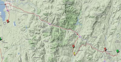
In this section I got lost. Instead of turning right when I got to Middlesex, I turned left onto Route 100B (thinking it was Route 2). After a bit I realized the river was flowing the wrong way (the Winooski was flowing with me, the Mad River was flowing against me...) and that I had climbed up into the mountains. I opened the MyTracks app, and saw that the shape of my trajectory wasn't what I expected.
When I got to the intersection of 100B and 100 I had to decide, do I backtrack down where I came, or follow the sign that said "Stowe"... knowing full well that having the name of a popular ski resort town on the sign in the direction I was headed probably meant climbing...I decided to go "see what I could see" by climbing another mountain. It turned out I was right, the worst climbing was yet to come on Route 100 (the section of 20-24k in the graph below):)
Created by My Tracks on Android.
Total Distance: 27.01 km (16.8 mi)
Total Time: 1:55:59
Moving Time: 1:38:22
Average Moving Speed: 16.47 km/h (10.2 mi/h)
Max Speed: 47.70 km/h (29.6 mi/h)
Min Elevation: 117 m (383 ft)
Max Elevation: 323 m (1059 ft)
Elevation Gain: 432 m (1418 ft)
Max Grade: 6 %
Min Grade: -6 %
Recorded: Tue Jun 28 08:36:28 EDT 2011
Activity type: cycling

When I figured I had reached the top I started a new track. Here we can see the profile of coming off the mountain, and then following Route 2 into Burlington. Just before Burlington there was a nasty hill (which my mom called "French Hill", I don't know what its actually called) where I could start to feel the wind coming off the lake, straight at me. It was a painful traffic filled ride into Burlington. The map which I got from Local Motion would have helped to avoid most of the traffic... I got to Burlington at around 3:00pm, went to Local Motion and headed south to get as far as I could that day.
Created by My Tracks on Android.
Total Distance: 53.97 km (33.5 mi)
Total Time: 4:28:18
Moving Time: 2:58:09
Average Moving Speed: 18.18 km/h (11.3 mi/h)
Max Speed: 57.60 km/h (35.8 mi/h)
Min Elevation: 5 m (18 ft)
Max Elevation: 332 m (1088 ft)
Elevation Gain: 459 m (1506 ft)
Max Grade: 4 %
Min Grade: -9 %
Recorded: Tue Jun 28 10:32:42 EDT 2011

The hills around Burlington were particularly frustrating, amplified by my being tired due to my unexpected detour that morning into the hills of Central Vermont and a wind from the south at around 20k/hr effectively putting my speed at only 10k an hour :( You can easily see the profile of the hills here in this graph.
Created by My Tracks on Android.
Total Distance: 14.53 km (9.0 mi)
Total Time: 1:38:48
Moving Time: 1:22:47
Average Moving Speed: 10.53 km/h (6.5 mi/h)
Max Speed: 49.50 km/h (30.8 mi/h)
Min Elevation: 1 m (3 ft)
Max Elevation: 88 m (288 ft)
Elevation Gain: 268 m (880 ft)
Recorded: Tue Jun 28 15:12:42 EDT 2011

Created by My Tracks on Android.
Total Distance: 29.79 km (18.5 mi)
Total Time: 2:37:11
Moving Time: 1:58:19
Average Moving Speed: 15.11 km/h (9.4 mi/h)
Max Speed: 44.10 km/h (27.4 mi/h)
Elevation Gain: 380 m (1247 ft)
Max Grade: 29 %
Min Grade: -9 %
Recorded: Wed Jun 29 06:19:06 EDT 2011

The Bridge at Crown Point was taken down about a year and a half ago, and replaced with a Ferry. So I even got to go on a ferry ride :) As you can see from the graph below, there weren't a lot of painful hills. They just started on the climb into to Port Henry. Route 9 is about the only way to go north on the New York side, some sections of the pavement are actually full of waves, not due to being covered in flood water, but due to waves of trucks crossing over it. The nice lady at the welcome center in Crown Point suggested that I gun it when there was low visibility. The cars and trucks were very nice, there wasn't too much traffic so they moved to the other side of the road when passing me. Although it could have been a bad section to ride on I found it was fine, maybe just because I was happy to have the wind at my back (my average speed was back up to 15k/hr).
Created by My Tracks on Android.
Total Distance: 32.69 km (20.3 mi)
Total Time: 3:32:43
Moving Time: 2:10:28
Average Moving Speed: 15.03 km/h (9.3 mi/h)
Max Speed: 40.70 km/h (25.3 mi/h)
Recorded: Wed Jun 29 11:31:28 EDT 2011

In this stretch I was very very happy for my rear view mirror. The road was smooth and I could take the entire lane to go down the hills (I had some pretty steep decent and I didn't want to melt my brakes).
I also realized why my Lake Champlain Bikeways Map had the entire New York side north of Whitehall green: it's some sort of nature preserve. What this means is that the land is too mountainous for anyone to have built any sizable farms, so there were so few residents that it's basically a state park. That's also why when you drive through upstate New York on 87, all you see are mountains and no towns. The cutest town was Westport and about the only place to buy groceries was at the Deli just south of Willisboro. The lady at the Welcome Center in Crown Point recommended camping at Noblewood Park. It was a pretty simple park, and didn't open until July 1st... so I was 3 days early.
Created by My Tracks on Android.
Total Distance: 40.67 km (25.3 mi)
Total Time: 3:26:49
Moving Time: 2:33:56
Average Moving Speed: 15.85 km/h (9.9 mi/h)
Max Speed: 55.02 km/h (34.2 mi/h)
Min Elevation: -4 m (-12 ft)
Max Elevation: 159 m (522 ft)
Elevation Gain: 653 m (2143 ft)
Max Grade: 5 %
Min Grade: -13 %
Recorded: Wed Jun 29 15:34:39 EDT 2011
Activity type: cycling

I did some leisurely hiking on Thursday Morning. I didn't have the strength to shift gears and still maintain momentum to accommodate for the roller coaster up hill shapes as can be seen in the graph below. The first bump is probably Rattlesnake mountain, the second and third bumps are on Highlands Road to Port Douglas. That road turned out to be the most beautiful part of my trip. It started off as a dirt road and became pavement after a little while. There were probably 2 cars the entire way, mostly just residents since the road basically lead from the middle of nowhere into the non-town of Port Douglas.
Created by My Tracks on Android.
Total Distance: 25.95 km (16.1 mi)
Total Time: 3:11:08
Moving Time: 2:00:07
Average Moving Speed: 12.96 km/h (8.1 mi/h)
Max Speed: 53.10 km/h (33.0 mi/h)
Min Elevation: -3 m (-10 ft)
Max Elevation: 183 m (600 ft)
Elevation Gain: 607 m (1992 ft)
Max Grade: 7 %
Min Grade: -13 %
Recorded: Thu Jun 30 09:10:06 EDT 2011

After eating lunch at the Ausable Chasm Cafe and using their Wifi the rest was downhill. I had no trouble getting to Platsburg. Relaxed for an hour or two on the beach, and then biked all the way to Saint Jean sur Richelieu. I didn't think I could make it but I managed to pull into town just as the last light was fading and all my fruit was gone. I parked by bike just infront of the entrance for the Ofenbach free open air concert, had 2 beers and 2 hotdogs to celebrate!

Created by My Tracks on Android.
Total Distance: 101.67 km (63.2 mi)
Total Time: 8:05:18
Moving Time: 7:35:34
Average Moving Speed: 13.39 km/h (8.3 mi/h)
Max Speed: 54.00 km/h (33.6 mi/h)
Min Elevation: 0 m (-1 ft)
Max Elevation: 85 m (279 ft)
Elevation Gain: 659 m (2162 ft)
Max Grade: 9 %
Min Grade: -8 %
Recorded: Thu Jun 30 13:30:36 EDT 2011
(For some reason my elevation stats are cut off, but suffice it to say, it was flat..)

After 4 years and no week long bike trips, I finally took a vacation. I biked from Montreal down the Chambly canal to the Richelieu river and around Lake Champlain. The easiest and most beautiful section of the lake (Alburg Springs to Burlington 78k) was substituted by a hilly segment after visiting family (East Montpelier to Burlington 87k).
Lessons Learned
* Lakes are rivers which couldn't drain because they are surrounded by hills; roads surrounding lakes are NOT flat.
* Biking on a canal or a river is much, much flatter than biking around a lake.
* Biking around Lake Champlain Difficulty: medium to hard.
* Biking on a canal difficulty: easy.
* Recommendation for biking around Lake Champlain: have a support vehicle which drives around your camping gear, don't haul it up the mountains unless that's your goal (biking uphill with weight).
Bottom Line
* Before this trip I was heavily biased towards flat bike trips with minimal wind. Now I realize I actually like biking in hills, even up hills, because there's much less wind. However, my next fully loaded bike trip will be on the Erie canal :)
Total Feet Climbed: 20,108 ft !!!!
Max Grade Uphill: 29 % !!!
Min Elevation: -119 ft (in Montreal)
Max Elevation: 1088 ft (in Moretown VT)

The View was spectacular:
Total Flat Tires: none :)
Total Mechanical Problems: none :)
Total Distance: 620+ km
Total Time: 37:38:40 hours
Average Moving Speed: 15.52 km/h
Max Speed: 57.6 km/h (in Moretown VT when I climbed up into the Mountains on my 3rd day by mistake)
Recorded: Sat Jun 25 - Friday July 1 2011
Activity type: Cycling
GPS tracked by My Tracks on Android.
Maps used:

Montreal -> Saint Jean sur Richelieu (La Montérégie Pistes Cyclables 2011)
Saint Jean sur Richelieu -> Alburg Springs (Revivez l'aventure de Champlain à vélo)
East Montpelier -> Burlington (Google Maps)
Burlington -> Shelburne (Burlington Walk Bike Council bike map 3rd edition)
Shelburne VT -> Crown Point NY (Lake Champlain Bikeways Map New Edition)
Crown Point NY -> Ausable Chasm (Lake Champlain Region Mapguide of Essex County NY)
Ausable Chasm -> Saint Jean sur Richelieu (Revivez l'aventure de Champlain à vélo)
The Map I wanted to use:
Google biking directions cached on my Android...
The trip in pictures
Click on the picture to see a slide show of the pictures of the trip.
The trip in Elevation Statistics
Here are the track by track stats generated using My Tracks. It's an Open Source GPS tracking app for Android which gives you complete access to your stats and will generates Google maps and Google earth data for you... Hopefully the door to a future with readily accessible maps and directions for biking anywhere!Montreal to Chambly: flat, mostly beautiful bike paths through the woods
Created by My Tracks on Android.
Total Distance: 41.92 km (26.0 mi)
Moving Time: 2:23:09
Average Moving Speed: 17.57 km/h (10.9 mi/h)
Max Speed: 33.35 km/h (20.7 mi/h)
Recorded: Sat Jun 25 12:13:48 EDT 2011
Montreal to Alburg Springs VT: flat, low traffic roads through fields and small villages from Saint Jean sur Richelieu to Alburg
Created by My Tracks on Android.
Total Distance: 96.21 km (59.8 mi)
Total Time: 7:52:20
Moving Time: 5:48:30
Average Moving Speed: 16.56 km/h (10.3 mi/h)
Max Speed: 32.85 km/h (20.4 mi/h)
Recorded: Sun Jun 26 09:48:38 EDT 2011
Montpelier to Moretown: good sized shoulder, low traffic, mostly paved except on Three Mile Bridge Road quite a few joggers and cyclists out training
In this section I got lost. Instead of turning right when I got to Middlesex, I turned left onto Route 100B (thinking it was Route 2). After a bit I realized the river was flowing the wrong way (the Winooski was flowing with me, the Mad River was flowing against me...) and that I had climbed up into the mountains. I opened the MyTracks app, and saw that the shape of my trajectory wasn't what I expected.
When I got to the intersection of 100B and 100 I had to decide, do I backtrack down where I came, or follow the sign that said "Stowe"... knowing full well that having the name of a popular ski resort town on the sign in the direction I was headed probably meant climbing...I decided to go "see what I could see" by climbing another mountain. It turned out I was right, the worst climbing was yet to come on Route 100 (the section of 20-24k in the graph below):)
Created by My Tracks on Android.
Total Distance: 27.01 km (16.8 mi)
Total Time: 1:55:59
Moving Time: 1:38:22
Average Moving Speed: 16.47 km/h (10.2 mi/h)
Max Speed: 47.70 km/h (29.6 mi/h)
Min Elevation: 117 m (383 ft)
Max Elevation: 323 m (1059 ft)
Elevation Gain: 432 m (1418 ft)
Max Grade: 6 %
Min Grade: -6 %
Recorded: Tue Jun 28 08:36:28 EDT 2011
Activity type: cycling
Moretown to Burlington: what goes up must come down...
When I figured I had reached the top I started a new track. Here we can see the profile of coming off the mountain, and then following Route 2 into Burlington. Just before Burlington there was a nasty hill (which my mom called "French Hill", I don't know what its actually called) where I could start to feel the wind coming off the lake, straight at me. It was a painful traffic filled ride into Burlington. The map which I got from Local Motion would have helped to avoid most of the traffic... I got to Burlington at around 3:00pm, went to Local Motion and headed south to get as far as I could that day.
Created by My Tracks on Android.
Total Distance: 53.97 km (33.5 mi)
Total Time: 4:28:18
Moving Time: 2:58:09
Average Moving Speed: 18.18 km/h (11.3 mi/h)
Max Speed: 57.60 km/h (35.8 mi/h)
Min Elevation: 5 m (18 ft)
Max Elevation: 332 m (1088 ft)
Elevation Gain: 459 m (1506 ft)
Max Grade: 4 %
Min Grade: -9 %
Recorded: Tue Jun 28 10:32:42 EDT 2011
Burlington to Charlotte: good sized shoulder lots of hills...
The hills around Burlington were particularly frustrating, amplified by my being tired due to my unexpected detour that morning into the hills of Central Vermont and a wind from the south at around 20k/hr effectively putting my speed at only 10k an hour :( You can easily see the profile of the hills here in this graph.
Created by My Tracks on Android.
Total Distance: 14.53 km (9.0 mi)
Total Time: 1:38:48
Moving Time: 1:22:47
Average Moving Speed: 10.53 km/h (6.5 mi/h)
Max Speed: 49.50 km/h (30.8 mi/h)
Min Elevation: 1 m (3 ft)
Max Elevation: 88 m (288 ft)
Elevation Gain: 268 m (880 ft)
Recorded: Tue Jun 28 15:12:42 EDT 2011
Charlotte to Button Bay: lots of hills...
Created by My Tracks on Android.
Total Distance: 29.79 km (18.5 mi)
Total Time: 2:37:11
Moving Time: 1:58:19
Average Moving Speed: 15.11 km/h (9.4 mi/h)
Max Speed: 44.10 km/h (27.4 mi/h)
Elevation Gain: 380 m (1247 ft)
Max Grade: 29 %
Min Grade: -9 %
Recorded: Wed Jun 29 06:19:06 EDT 2011
Button Bay to Port Henry: flat and beautiful scenery
The Bridge at Crown Point was taken down about a year and a half ago, and replaced with a Ferry. So I even got to go on a ferry ride :) As you can see from the graph below, there weren't a lot of painful hills. They just started on the climb into to Port Henry. Route 9 is about the only way to go north on the New York side, some sections of the pavement are actually full of waves, not due to being covered in flood water, but due to waves of trucks crossing over it. The nice lady at the welcome center in Crown Point suggested that I gun it when there was low visibility. The cars and trucks were very nice, there wasn't too much traffic so they moved to the other side of the road when passing me. Although it could have been a bad section to ride on I found it was fine, maybe just because I was happy to have the wind at my back (my average speed was back up to 15k/hr).
Created by My Tracks on Android.
Total Distance: 32.69 km (20.3 mi)
Total Time: 3:32:43
Moving Time: 2:10:28
Average Moving Speed: 15.03 km/h (9.3 mi/h)
Max Speed: 40.70 km/h (25.3 mi/h)
Recorded: Wed Jun 29 11:31:28 EDT 2011
Port Henry to Willisboro: Hills of hell part 1
In this stretch I was very very happy for my rear view mirror. The road was smooth and I could take the entire lane to go down the hills (I had some pretty steep decent and I didn't want to melt my brakes).
I also realized why my Lake Champlain Bikeways Map had the entire New York side north of Whitehall green: it's some sort of nature preserve. What this means is that the land is too mountainous for anyone to have built any sizable farms, so there were so few residents that it's basically a state park. That's also why when you drive through upstate New York on 87, all you see are mountains and no towns. The cutest town was Westport and about the only place to buy groceries was at the Deli just south of Willisboro. The lady at the Welcome Center in Crown Point recommended camping at Noblewood Park. It was a pretty simple park, and didn't open until July 1st... so I was 3 days early.
Created by My Tracks on Android.
Total Distance: 40.67 km (25.3 mi)
Total Time: 3:26:49
Moving Time: 2:33:56
Average Moving Speed: 15.85 km/h (9.9 mi/h)
Max Speed: 55.02 km/h (34.2 mi/h)
Min Elevation: -4 m (-12 ft)
Max Elevation: 159 m (522 ft)
Elevation Gain: 653 m (2143 ft)
Max Grade: 5 %
Min Grade: -13 %
Recorded: Wed Jun 29 15:34:39 EDT 2011
Activity type: cycling
Willisboro to Ausable Chasm: Hills of hell part 2
I did some leisurely hiking on Thursday Morning. I didn't have the strength to shift gears and still maintain momentum to accommodate for the roller coaster up hill shapes as can be seen in the graph below. The first bump is probably Rattlesnake mountain, the second and third bumps are on Highlands Road to Port Douglas. That road turned out to be the most beautiful part of my trip. It started off as a dirt road and became pavement after a little while. There were probably 2 cars the entire way, mostly just residents since the road basically lead from the middle of nowhere into the non-town of Port Douglas.
Created by My Tracks on Android.
Total Distance: 25.95 km (16.1 mi)
Total Time: 3:11:08
Moving Time: 2:00:07
Average Moving Speed: 12.96 km/h (8.1 mi/h)
Max Speed: 53.10 km/h (33.0 mi/h)
Min Elevation: -3 m (-10 ft)
Max Elevation: 183 m (600 ft)
Elevation Gain: 607 m (1992 ft)
Max Grade: 7 %
Min Grade: -13 %
Recorded: Thu Jun 30 09:10:06 EDT 2011
Ausable Chasm to Saint Jean sur Richelieu: one loooong afternoon ending with an Offenbach Concert in the park!!!
After eating lunch at the Ausable Chasm Cafe and using their Wifi the rest was downhill. I had no trouble getting to Platsburg. Relaxed for an hour or two on the beach, and then biked all the way to Saint Jean sur Richelieu. I didn't think I could make it but I managed to pull into town just as the last light was fading and all my fruit was gone. I parked by bike just infront of the entrance for the Ofenbach free open air concert, had 2 beers and 2 hotdogs to celebrate!

Created by My Tracks on Android.
Total Distance: 101.67 km (63.2 mi)
Total Time: 8:05:18
Moving Time: 7:35:34
Average Moving Speed: 13.39 km/h (8.3 mi/h)
Max Speed: 54.00 km/h (33.6 mi/h)
Min Elevation: 0 m (-1 ft)
Max Elevation: 85 m (279 ft)
Elevation Gain: 659 m (2162 ft)
Max Grade: 9 %
Min Grade: -8 %
Recorded: Thu Jun 30 13:30:36 EDT 2011
(For some reason my elevation stats are cut off, but suffice it to say, it was flat..)
Subscribe to:
Posts (Atom)
